
Newly enacted Ordinances:
Ordinance No. 2-26; An ordinance adopting a revision and codification of the ordinances of the Town of Ottawa, WI [ Ordinance ]
Ordinance No. 2-26b; An ordinance to designate Hardscrabble Road and Piper Road as Class "B" Highways [ Ordinance ]
Ordinance No. 3-26; An ordinance accepting the Village of Palmyra as a contract member to the Lake Country Municipal Court [ Ordinance ]
Ordinance No. 4-26; An ordinance to adopt a comprehensive development plan map amendment [ Ordinance ]
Ordinance No. 5-26; An ordinance regarding the use of aerators on public inland waters [ Ordinance ]
*******************************************************************************************************************************************
*******************************************************************************************************************************************
Notice that the Assessment Roll is Open for Examination and Open Book
STATE OF WISCONSIN
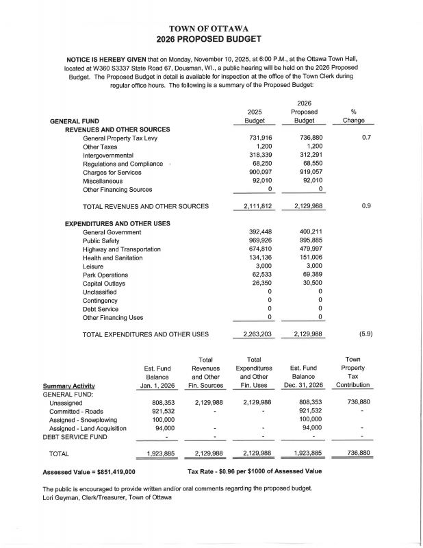
Town of Ottawa, Waukesha County. Pursuant to Sec. 70.45 of the Wis. Statutes, the Assessment Roll for the year 2026 will be open for public examination starting the 8th day of June, 2026, from 9:00 A.M. to 3:00 P.M., Monday through Thursday, and 9:00 A.M to 11:00 A.M on Fridays.
Additionally, the Town Assessor, Schultz Appraisal Agency, shall be available at the Town Hall, W360S3337 State Road 67, Dousman, WI, for OPEN BOOK, on Tuesday, June 9, 2026, between the hours of 10:00 A.M. and 12:00 Noon. Instructional material will be provided at the open book to persons who wish to object to valuation under 70.47, Wis. Stats.
Notice of Meeting to Adjourn Board of Review to Later Date
Town of Ottawa, Waukesha County
The Board of Review will meet on the 11th day of May, 2026 at 6:00 p.m. at the Town Hall, W360S3337 State Road 67, Dousman, WI, for the purpose of calling the Board of Review into session during the 45 day period beginning on the 4th Monday of April pursuant to Wis. Stat. § 70.47(1).
Due to the fact the assessment roll is not completed at this time, the Board of Review will be adjourned until the 25th day of June, 2026, at 6:00 p.m.
Please be advised of the following requirements to appear before the Board of Review and procedural requirements if appearing before the Board of Review:
- After the first meeting of the Board of Review and before the Board’s final adjournment, no person who is scheduled to appear before the Board of Review may contact, or provide information to, a member of the Board of Review about the person’s objection except at a session of the Board. Open Book shall occur no less than 7 days prior to the Board of Review.
- The Board of Review may not hear an objection to the amount or valuation of property unless, at least 48 hours before the Board of Review’s first scheduled meeting, the objector provides to the Board of Review Clerk written or oral notice of an intent to file an objection, except that upon a showing of good cause and the submission of a written objection, the Board shall waive that requirement during the first 2 hours of the Board of Review’s first scheduled meeting, and the Board of Review may waive that requirement up to the end of the 5thday of the session or up to the end of the final day of the session if the session is less than 5 days, with proof of extraordinary circumstances for failure to meet the 48-hour notice requirement and failure to appear before the Board of Review during the first 2 hours of the fist scheduled meeting.
- Objections to the amount of valuation of property shall first be made in writing and filed with the Board of Review Clerk of the Board of Review within the first 2 hours of the Board of Review’s first scheduled meeting, except that, upon evidence of extraordinary circumstances, the Board of Review may waive that requirement up to the end of the 5th day of the session or up to the end of the final day of the session if the session is less than 5 days. The Board of Review may require objections to the amount or valuation of property to be submitted on forms approved by the Department of Revenue, and the Board of Review shall require that any forms include stated valuations of the property in question. Persons who own land and improvements to that land may object to the aggregate valuation of that land and improvements to that land, but no person who owns land and improvements to that land may object only to the valuation of that land or only to the valuation of improvements to that land. No person may be allowed in any action or proceedings to question the amount or valuation of property unless the written objection has been filed and that person in good faith presented evidence to the Board of Review in support of the objections and made full disclosure before the Board of Review, under oath, of all of that person’s property liable to assessment in the district and the value of that property. The requirement that objections be in writing may be waived by express action of the Board.
- When appearing before the Board of Review, the objecting person shall specify in writing the person’s estimate of the value of the land and of the improvements that are the subject of the person’s objection and specify the information that the person used to arrive at that estimate.
- No person may appear before the Board of Review, testify to the Board of Review by telephone or object to a valuation; if that valuation was made by the Assessor or the Objector using the income method of valuation, unless no later than 7 days before the first meeting of the Board of Review, the person supplies the Assessor all the information about income and expenses that the assessor requests, as specified in the Assessor’s manual under Sec. 73.03 (2a), Wis. Stats., that the Assessor requests. The Town of Ottawa has an ordinance for the confidentiality of information about income and expenses that is provided to the Assessor under this paragraph that provides exceptions for persons using information in the discharge of duties imposed by law or the duties of their office or by order of a court. The information that is provided under this paragraph, unless a court determines that it is inaccurate, is not subject to the right of inspection and copying under Section 19.35(1), Wis. Stats.
- The Board of Review shall hear upon oath, by telephone, all ill or disabled persons who present to the Board of Review a letter from a physician, physician assistant, or advanced practice nurse prescriber certified under Wis. Stat. 70.47(3)(a), that confirms their illness or disability. No other persons may testify by telephone unless the Board, in its discretion, has determined to grant a property owner’s or their representative’s request to testify under oath by telephone or written statement.
- No person may appear before the Board of Review, testify to the Board of Review by telephone, or contest the amount of any assessment unless, at least 48 hours before the first meeting of the Board of Review, or at least 48 hours before the objection is heard if the objection is allowed under Wis. Stat. 70.47(3)(a), that person provides to the Board of Review Clerk as to whether the person will ask for the removal of a member of the Board of Review and, if so, which member, and provides a reasonable estimate of the length of time the hearing will take.
- No person shall be allowed to appear before the board of review, to testify to the board by telephone or to contest the amount of any assessment of real or personal property if the person has refused a reasonable written request by certified mail of the assessor to enter onto property to conduct an exterior view of the real or personal property being assessed.
Lori Geyman, Clerk, Town of Ottawa
****************************************************************************************************************************************
***********************************************************************************************************************************************************************
N:\PRKANDLU\Planning and Zoning\Community Assistance\T OTTAWA\Town Land Use Plan\2009 Comp Dev Plan Smart Growth compliance update\Annual Amendments\2020 Annual Amendments\2020 PV Town of Ottawa CDP public hearing notice.docx
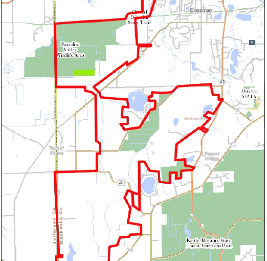
CDP BOUNDARY UPDATE MAP
|